-

by
Joe Lombardi
National Interest
Brand-new snowfall projections have been released for a major winter storm that is heading toward the East Coast.Click here for a new, updated story - Here's Timing, Latest Snowfall Predictions For Major New Winter StormIt's expected to arrive in the Northeast late Wednesday afternoon, Feb. 19, moving up from the south before winding down around midday on Thursday, Feb. 20, according to ...
-
by
Joe Lombardi
National Interest
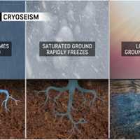
A bitter blast of Arctic air and frigid wind chills that arrived in the Northeast following a major winter storm comes with an unexpected twist: a natural phenomenon called frost quakes.Unlike earthquakes, they are not caused by tectonic plates, but rather, cold conditions.Also known as cryoseisms, they can be loud enough to jolt people awake in the middle of the night, according to ...
-
by
Joe Lombardi
National Interest
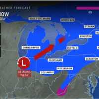
Back-to-back storm threats are on target for the Northeast in the coming days.New Update: First Snowfall Projections Released For New Winter Storm - Up To Half-Foot Predicted In These SpotsThe first system will move from the west to the east, bringing a mix of rain, sleet, and snow Friday night, Jan. 17 into Saturday, Jan. 18. (See the first image above from AccuWeather.)More ...
-
by
Cecilia Levine
Weather
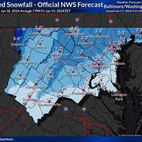
The National Weather Service has released a brand-new map showing projected snow totals coming to the mid-Atlantic later this week.Wednesday, Jan. 17 is expected to be "very cold" with temps struggling to reach the freezing mark southeast of Washington DC in the afternoon, the NWS said. Sunny skies are expected today, but it will remain very cold.Posted by US National Weather Service ...
-
by
Ben Crnic
Breaking News
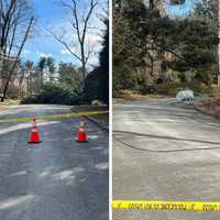
Heavy wind gusts from a powerful cold front traveling through the Northeast are causing thousands of people to lose power throughout Westchester County. The cold front, arriving in the area on Friday, Feb. 3, is bringing gusts as strong as 35 miles per hour to the region, along with Arctic air. The combination of the chilled air and wind will make it feel below-freezing at times, ...
-

by
Joe Lombardi
Weather
As a potentially historic, extreme storm has already dumped around 2 feet of snowfall in the Buffalo area, with more to come, residents in this region may see a round of light snow before a winter-like blast of Arctic air.Friday, Nov. 18 will be mostly sunny, breezy, and brisk with a high temperature in the mid 40s, according to the National Weather Service.After nightfall, there will ...
-

by
Cecilia Levine
Weather
While you were cooling off at the pool this week, the Farmers' Almanac released its predictions for Winter 2022-23."A cold December and a very cold January might make readers in the Northeast shake and shiver," said the FA, who released its extended winter forecast on Wednesday, Aug. 3.Winter is expected to make an appearance much earlier this year than last, with December 2022 looking ...
-

by
Joe Lombardi
Weather
A band of snowfall moving from north to south is causing slippery roads during the morning commute on Monday, March 28, leading some schools to delay starting times.For a look at areas affected by the band, including parts of the eastern Hudson Valley, central Connecticut and eastern Long Island, check the radar image above.Wind-chill values throughout the region are bone-chilling as a ...
-

by
Joe Lombardi
Weather
The arrival of Arctic air will make the second half of the final weekend of March feel more like it's the middle of winter than the start of spring, with accumulating snow expected in parts of the Northeast."Conditions over the next few days will be reminiscent of mid-January," said AccuWeather Meteorologist Randy Adkins.Sunday, March 27 will be partly sunny and blustery with a high ...
-

by
Joe Lombardi
Weather
As a bitter blast of Arctic air takes hold in the region, a new storm system has the potential to bring the latest round of accumulating snowfall.The system is on track for Tuesday, Jan. 25 into Wednesday, Jan. 26.The days leading up to then will be dry and continued cold.Saturday, Jan. 22 will be mostly sunny with a high in the mid 20s and wind-chill values between zero degrees and 10 ...
-

by
Joe Lombardi
Weather
As a major winter storm takes aim on parts of the East Coast, a bitter blast of Arctic air accompanied by strong winds will make it feel like it's around zero in this region.Friday, Jan. 21 will become mostly sunny with a high temperature in the low 20s and wind-chill values between zero and 10 degrees as winds gust up to 20 miles per hour. (See the first image above.)"Be sure to wear ...
-

by
Joe Lombardi
Weather
The first snowfall projections have been released for a slow-moving late-week storm taking aim on the region.How Much Snow Did You Get? A Look At Totals Throughout Region From Nor'easterAccording to AccuWeather, the system expected for Thursday, Feb. 11 into Friday, Feb. 12 could result in accumulations of 6 to 12 inches for parts of the region. (Areas in dark blue in the first image ...
-

by
Joe Lombardi
Weather
A system that brought a mix of accumulating snow, sleet, and rain to the region will be followed by a blast of Arctic air and then the potential for an even more significant storm.The storm moving west to east is expected to affect the region on Sunday, Jan. 31, and Monday, Feb. 1. (See the first image above.)"How much snow falls from the mid-Atlantic and central Appalachians to New ...
-

by
Joe Lombardi
Weather
It's beginning to look a lot like we may be getting a new round of snowfall on Christmas.Long-range forecast models now show the potential for a storm powered by Arctic air bringing snow, sleet, and rain expected to develop on Christmas Eve, Thursday, Dec. 24, and continue into Christmas Day, Friday, Dec. 25."The snow area is going to be smaller, and at this point, we’re not going to be ...
-
by
Joe Lombardi
Weather
Click here for an updated story: Christmas Eve Storm To Bring Drenching Rain, Strong Winds Followed By Snow Chance On ChristmasIt's beginning to look a lot like we may be getting a new round of snowfall on Christmas.Long-range forecast models now show the potential for a storm powered by Arctic air bringing snow, sleet, and rain expected to develop on Christmas Eve, Thursday, Dec. 24, ...
-

by
Joe Lombardi
Weather
A round of scattered snow showers and flurries across the region will be followed by a blast of Arctic air that will dip temperatures in the teens overnight.The light snow is expected sometime after 8 p.m. Sunday, Jan. 19. Little or no accumulation is expected.Related story: How Much Snow Did You Get? A Look At Totals From Throughout The RegionThen comes the plunge in temperatures ...
-

by
Joe Lombardi
Weather
New snowfall projections for the complex storm that will sweep through the Northeast show widely varying totals, with parts of the region seeing up to nearly half a foot but areas farther south and east expected to get just an inch or less of accumulation.Higher accumulations will be farther north and west. (See first image above.) Dutchess County should get about 3 inches of ...
-

by
Joe Lombardi
Weather
Projected snowfall totals have been released for the storm that will sweep through the area early this week, ushering in a freeze-up and a new round of Arctic air.Projected snowfall totals from the storm show generally 1 to 3 inches for most of the area, with 3 to 6 inches farther to the west, from Tuesday night, Jan. 29 into Wednesday morning, Jan. 30. (See first image above.)There is ...
-

by
Joe Lombardi
Weather
A new round of Arctic air will arrive after a midweek storm that will bring a chance of snow followed by steady rain to the region.Dr. Martin Luther King Jr. Day, Monday, Jan. 21, will be partly sunny, icy and frigid, with a high temperature in the lower teens and wind-chill values between -5 and -15 during the day. Winds of about 20 mph with gusts up to 45 mph could cause power ...
-
by
Joe Lombardi
Weather
Click here for an updated story: Midweek Storm To Bring Precipitation Over 24-Hour Period, But Will We See Any Snow?A new round of Arctic air will arrive after a midweek storm that will bring a chance of snow followed by steady rain to the region.Tuesday, Jan. 22 will be mostly sunny with a high in the mid- to upper-20s and the overnight low in the upper teens.The storm will arrive ...
-

by
Joe Lombardi
Weather
The complex storm system that is bringing more freezing rain and rain than snow to the area will bring a big change in the weather pattern.Areas north of I-287 and the Merritt Parkway are seeing an icy and slippery wintry mix on Sunday morning, Jan. 20. Significant snowfall totals of up to a foot are expected north of I-84.A Winter Storm Warning remains in effect until 6 p.m. Sunday for ...
-

by
Joe Lombardi
Weather
The major, complex three-pronged storm that will bring a mix of snow and freezing rain followed by icy/slippery conditions is looking every bit as strong as expected as it gets set to arrive in the area on Saturday, Jan. 19.A total accumulation of between 3 to 7 inches of snowfall is expected for most of the region, with up to 12 inches farthest north. (See second image above.)Ice ...
-

by
Joe Lombardi
Weather
A major storm the National Weather Service is calling a "multi-hazard" is closing in on this region and the entire Northeast.A Winter Weather Advisory is in effect from Saturday at 4 p.m. until 10 a.m. Sunday for North Jersey and surrounding areas.Mixed precipitation is expected (see second image above) with a total accumulation of 2 to 4 inches of snowfall for most of the area.Ice ...
-
by
Joe Lombardi
Weather
Click here for an updated story: Get Set For Snow, Freezing Rain, Followed By Flash Freeze, IcingA major storm the National Weather Service describes as "multi-hazard" is closing in on this region and the entire Northeast.A Winter Storm Warning is now in effect from noon Saturday, Jan. 19 until 6 p.m. Sunday, Jan. 20 for areas north of I-287 and the Merritt Parkway. (Shown in pink in ...
-

by
Joe Lombardi
Weather
An overnight round of light snow resulted in a coating to up to an inch of accumulation on Friday morning.But that was just a very small taste of what's in store as a major storm the National Weather Service describes as "multi-hazard" comes this weekend. The storm's biggest threat will be ice, especially north of I-287 and the Merritt Parkway and just south of I-84, where a ...
-

by
Joe Lombardi
Weather
Projected snowfall and ice accumulations for the major winter snow that will sweep through the area this weekend have been released, but a preview of that system will come with a separate system bringing light snow overnight into Friday.The back-to-back storms will be followed by a blast of Arctic Air and a dangerous wintry mix with an accumulation of ice that could cause power outages ...
-

by
Joe Lombardi
Weather
A burst of Arctic air will sweep in following Wednesday's winter storm and result in a quick freeze-up that could make for more slippery travel for the Thursday morning commute.Overnight low temperatures will fall into the mid-teens, with wind-chill factors between 10 and 15 degrees.School delays and even some closings are possible.Thursday will be a sunny day but bitterly cold, with a ...


